
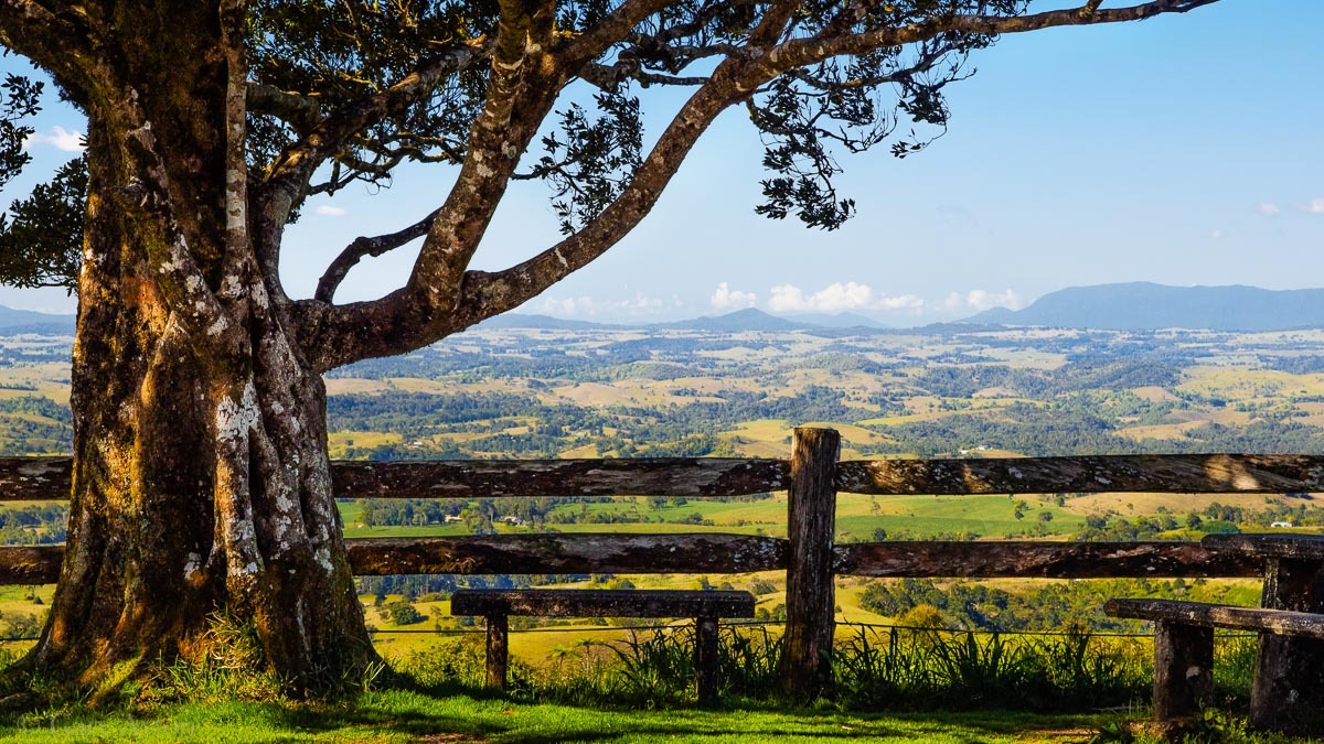
The Atherton Tableland is an elevated rainforest plateau 700m to 1000m above sea level which is littered with ancient volcanic hills, valleys, waterfalls and crater lakes making it a photographer’s and naturalist’s delight and is some 4 degrees Celsius cooler than Cairns and unlike the coast, you will need a jumper or cardigan for evening wear.
There are essentially 4 access roads from the coast – each will involve 20-30minutes of slowish winding roads up the mountains to get there:
- Rex Range Road from Mossman
- Kennedy Highway via Kuranda from Cairns
- Gillies Highway via Gordonvale from Cairns
- Palmerston Highway from Innisfail
The main town is Atherton with Mareeba to the north which is drier and with clearer skies.
Attractions near Mareeba:
- Mareeba Tropical Wetlands and Savannah Reserve with Jabiru Safari Lodge, which is a great for bird watchers. Further north are drier woodlands with a multitude of tall termite mounds.
- Granite Gorge Nature Park – great for picnics and their local unique wallaby species
- The Coffee Works – for coffee and chocolate
- Golden Drop Winery – mango wines
Central tablelands region:
- Atherton township
- Hastie’s swamp bird watching
- Wongabel State Forest rainforest walk track 2.6km
- Mt Hypipamee National Park – unique steep walled crater lake and adjacent Dinner Falls cascades make for a pleasant short walk and nice photo opportunities
- Bromfield’s Crater
- historic mining town of Herberton with its reconstructed 19thC mining township as a tourist attraction
- Yungaburra heritage township, Nick’s Swiss-Italian restaurant and the massive curtain fig tree
- Lake Tinaroo and dam
- Lake Barrine lake cruises and rainforest walk through 2 giant Kauri pine trees
- Lake Eacham National Park
- Malanda and Malanda Falls
- Nerada tea farm and their resident wild Lumholtz tree kangaroos
- Bartle Frere mountain hiking for the fit (Queensland’s tallest mountain at 1622m)
Southern tablelands region:
- Tarzali Lakes tourist attraction (privately owned) for platypus sightings and farmed barramundi fishing
- the famous Millaa Millaa falls and the waterfall circuit drive including Zillie Falls and Ellinjaa Falls
- Ravenshoe, Queensland’s highest town and the Millstream Falls
- Tully Gorge and Misty Mountain rainforest bushwalks – 36km one-way Koolmoom Creek Track (several short loops possible); 19km one way Cardwell Range Track; 15km one way difficult Cannabullen Creek Track; 26km one way Gorrell Track; BEWARE the stinging trees!!! Bring radio beacon or satellite phone!! Most pleasant May-Oct but heavy rains any time of year can make creeks impassable! Camping requires a permit. Tracks are wet and slippery and leeches abound;
Millaa Millaa lookout – Olympus OM-D
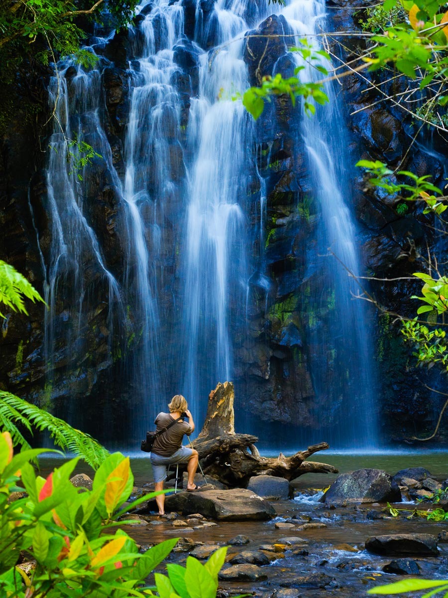
Ellinjaa falls, and yes, there are annoying Canikon photographers who take centre stage with their tripods. I decided not to wait for the queue of them and shot this long exposure hand held standing on top of a rock in the middle of the stream using my Olympus OM-D with its amazing built in image stabiliser which allows these hand held longer exposure shots without a tripod.
For bird watchers and ornithologists:
Mt Lewis NP in Nov-April but check road conditions as gravel road: upland rainforest birds such as Golden Bowerbird, Chowchilla, Blue-faced Parrot Finch.
Abattoir Swamp: boardwalk and hide – when paperbarks are flowering: lorikeets, honeyeaters; crakes and rails; Northern Fantail at the car park;
Davies Creek Falls NP via gravel road: granite boulder falls; Pale-headed rosella, White-cheeked honeyeater, Lemon-bellied flycatcher;
Barron Falls NP: Pied Monarch, Yellow-breasted Boatbill.
Mt Molloy: Red-winged parrot, Great Bowerbird are found near the school;
Malanda Falls Conservation Park: Aust. Brush Turkey, Orange-footed scrubfowl, Atherton scrubwren, Macleay’s Honeyeater, Eastern Whipbird.
Lake Mitchell man made wetland: Black-necked stork and dry country birds in the woodlands.
Crater lakes NP: Double-eyed Fig-parrot, Victoria’s Riflebird; Tooth-billed Bowerbird builds courts close to the track in breeding season (Sept-Jan).
Nardello’s Lagoon: waterbirds; White-breasted Sea Eagle and Swamp Harrier in Sept-Dec; Red-tailed Black Cockatoos; Sulphur-crested cockatoos;
Bromfield Swamp: unique volcanic crater is a nesting site for hundreds of Sarus Crane and Brolga in Apr-Nov best at dusk when they return home to roost, or early morning.
Hastie’s Swamp: home to 220 bird species; two-storey bird hide; Magpie Goose, Plumed Whistling Duck, Pink-eared duck, White-headed Stilt;
Millaa Millaa Falls: Yellow-throated scrubwren, Bower’s Shrike-thrush
Wongabel State Forest: Emerald Dove, Wompoo Fruit Dove, White-throated Treecreeper, Ferenwren, Bower’s Shrike-thrush;
Mt Hypipamee NP: Fernwren, Bridled Honeyeater, Grey-headed Robin, Chowchilla (early morning), Golden Bowerbird, Southern Cassowary
Kaban: drier western edge; Painted Button-Quail, Little Lorikeet, Fuscous Honeyeater, Varied Sittella, Crested Shrike-tit, Eastern Yellow Robin;
Tully Falls Rd: Pale yellow Robin
Innisfail region:
- several waterfalls along the Palmerston Highway
- Mamu Tropical Skywalk tourist attraction – boardwalks in the tree tops
- Paronella Park historic rainforest mansion
- Eubanangee Swamp National park near the coast and Josephine Falls
Further west from the Tablelands:
- historic outback mining town of Chillagoe with limestone caves to explore
- unique Undara Lava Tubes
Finally, a little history:
The tablelands were originally inhabited by approx. 16 Aboriginal indigenous tribes who created clearings or “pockets” by using fire to clear the rainforest undergrowth and make it easier to hunt wallabies.
They had to deal with the volcanic eruptions, the most recent eruptions were approximately 10,000 years ago.
Then along came the British and Chinese miners in the mid 19th century when gold and tin was discovered resulting in the mining towns of Herberton and Chillagoe. The whites ran into conflict with the indigenous peoples and hence the naming of Butcher Creek.
For more indigenous history of the region see here.
Once the Europeans and Chinese gained access via Cobb and Co coaches (initially from Port Douglas through to Atherton then to Herberton via the “Mulligan Highway”), the timber-getters moved in and dominated much of the central tablelands and clearing much of the rainforest for its valued timber, especially Red cedar (Toona ciliata), but also walnut, Queensland maple, Silky Oak, Silkwood, Black Bean, Silver Ash and Kauri Pine.
A shorter route was established from Cairns called Robson’s Track – near the current Gillies Highway.
The 1st permanent white settler in the Yungaburra region was John Stewart in 1890. By 1903, the railway from Cairns had reached Atherton, and then was extended to Yungaburra in 1910 and operated until it closed in 1964.
Cyclone Larry in 2006 caused considerable damage to the Tablelands, snapping many trees off at 4m from the ground and damaging buildings.


